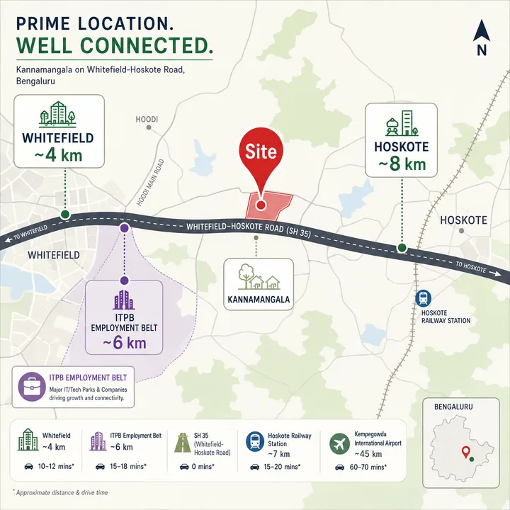
The Jurisdiction Frame, in Full
| Layer | This belt |
|---|---|
| District | Bengaluru Urban |
| Taluk | Bengaluru East Taluk (headquarters at Krishnarajapura) |
| Hobli | Bidarahalli Hobli |
| Revenue villages | Khajisonnenahalli, Kannamangala, Seegehalli (Bangalore East), Doddabanahalli |
| City corporation | None. Outside all five |
| Local body | Grama panchayat administration |
| PIN | 560115 across the belt; contested at its southern edge |
| Highway | State Highway 35 |
| Planning authority | Bangalore Development Authority — unconfirmed |
Bengaluru Urban district's own administrative tables record Bengaluru East Taluk as carrying three hoblis, eleven grama panchayats and 148 villages, with no urban local body. Bidarahalli is one of those three hoblis, and the villages this project sits among are four of those 148. That one row of a government table answers more buyer questions than any brochure on this corridor: it fixes the district, the taluk, the hobli, the absence of a municipal body, and the fact that land here is administered through the panchayat system.
Which Ward Is It In? There Isn't One
This is asked constantly and answered almost never.
Bengaluru's old single city corporation was dissolved on 2 September 2025 under the Greater Bengaluru Governance Act, and five new corporations were constituted in its place. One of them, Bengaluru East City Corporation, covers about 168 sq km across 50 wards — the largest area and fewest wards of the five. Its territory reaches up this road as far as Belathur, which is Ward 30, and Kadugodi, which is Ward 31.
It stops there. The Khajisonnenahalli-Kannamangala-Seegehalli-Doddabanahalli belt lies north of that boundary and inside no corporation at all, which is why an independent geocode of any point in it returns a district and a taluk but no municipality. The honest answer to "what is the ward number" is that there is none to give, and any listing supplying one for this belt has either guessed or is describing land further south.
Three consequences follow, and they matter more than the label:
- Property tax and civic services run through the grama panchayat, not a corporation. The service standard, the tax basis and the escalation path are all different.
- Khata class is a live question here, not a formality. Panchayat-issued and corporation-issued records are not the same instrument, and Karnataka's e-khata rollout has changed what a lender and a sub-registrar will accept. Ask which class the land holds today and which will be issued at registration — in writing, against the sanctioned extent.
- Water and sewerage are not municipal by default. Nothing in the public record establishes a piped city connection to this belt, which makes borewell yield, tanker dependence and the scheme's own treatment capacity real questions rather than boilerplate.
One further check on any document you are shown: an approval note still naming Bengaluru's old single corporation as the sanctioning body is out of date on its face — quite apart from the fact that this belt has never fallen inside a city corporation at all.
The PIN Code, and Why It Is Genuinely Contested Here
The corridor crosses three PIN codes in roughly 15 km, and they do not line up with the taluk boundaries in the way people assume.
| PIN | What it covers on this road | Administration |
|---|---|---|
| 562114 | The Hoskote end, including the Pettanahalli stretch | Hoskote taluk, Bengaluru North district |
| 560115 | Khajisonnenahalli, Kannamangala, Seegehalli (Bangalore East) | Bidarahalli Hobli, Bengaluru East Taluk, outside any corporation |
| 560067 | Belathur and Kadugodi at the southern end | Bengaluru East Taluk, inside Bengaluru East City Corporation |
Now the caveat, and it is real rather than a hedge. Doddabanahalli sits on the seam between 560115 and 560067, and our sources disagree about which covers it. The stronger of the two is the primary one: the Karnataka RERA record for the developer's own completed community on this road carries a survey-numbered address — Sy. No. 109/1, 109/2, 109/10 and 110, Doddabanahalli Village, Bidarahalli Hobli, Bengaluru East Taluk, Bengaluru Urban district — with PIN 560067. Against that, a portal address for the same village, with no survey numbers attached, reads 560115. And a school whose own website publishes its campus as Kannamangala Village, Bidarahalli Hobli, East Taluk also gives 560067, on land the same records place in the 560115 belt.
We do not assert either code for Doddabanahalli, and no page on this site does. Note the shape of the disagreement, because it is instructive: the reading with survey numbers behind it is the one giving 560067, and a survey-numbered address is the only kind that can be checked against a revenue record at all.
We are not going to pick one. Neither reading is verified, and the reason both can appear is worth understanding: a PIN code is a postal delivery unit. It is not a revenue boundary, not a hobli boundary and not a municipal boundary, and nothing requires it to agree with any of them. The 560067 code covers land both inside and outside Bengaluru East City Corporation.
So the operative advice is simple. The PIN governing a specific parcel is the one on its khata and its postal record for those survey numbers — not the one on a brochure, a portal or a map pin. Confirm it against the survey numbers once a parcel exists, and never treat a PIN as evidence of which body will collect your property tax.
What SH-35 Actually Is
The Whitefield-Hoskote Road is State Highway 35, an 89 km Karnataka highway running from Sidlaghatta in the north through Hoskote, Kadugodi, Whitefield, Varthur, Gunjur, Sarjapur and Attibele to Anekal in the south. It is maintained by the Karnataka Public Works Department. Most of it is two-lane; the section between Kadugodi and Varthur-Kodi is four-lane.
Two details of its geometry matter, because most descriptions of this corridor get them wrong.
SH-35 does not leave the national highway inside Hoskote town. The junction where the two separate sits roughly 3.5 km south-west of Hoskote town centre, so a trip from the town to these villages runs on the national highway first and joins the Whitefield-Hoskote Road only afterwards. Hoskote town centre to Belathur is about 11.5 km by road for that reason, and only around 5 km of it is on the road this project is named for.
The named SH-35 mainline between that junction and Kadugodi is about 5.2 km, continuing as Kadugodi Main Road for roughly another kilometre. This belt sits inside that span. It is a short road carrying a long name, which is part of why so much marketing copy stretches the label over projects nowhere near it.
SH-35 Is Not Old Madras Road: a Confusion Worth Resolving
This is the most expensive misunderstanding on this side of the city, and an easy one to make, because two different highways both run east and both pass Hoskote.
Old Madras Road is NH-75, a national highway running east out of Krishnarajapura through Hoskote and on toward Kolar. The Whitefield-Hoskote Road is SH-35, a state highway that meets NH-75 south-west of Hoskote town and then runs south to Whitefield. They converge near Hoskote and diverge everywhere else.
A project described as being "on the Hoskote road" can sit on either, and they are not interchangeable:
- Different taluk and district. The NH-75 side east of the town is Hoskote taluk, Bengaluru North district, PIN 562114. This belt is Bengaluru East Taluk, Bengaluru Urban, PIN 560115.
- Different planning regime. The 562114 end is governed by Hoskote Planning Authority, a local planning authority under BMRDA. That authority does not govern this belt.
- Different distances. From a point on the NH-75 side east of Hoskote town, reaching the SH-35 mainline at all means roughly 7.5 km west on the national highway first.
- Different prices. Rates on the two arterials are not the same, and a comparable drawn from the wrong one misleads by a wide margin.
A third arterial complicates any distance claim here. Routing engines asked for the fastest way from Hoskote town to the Whitefield technology cluster prefer a route of about 16.5 km running mainly along the Dabaspete-Hosur alignment — the Satellite Town Ring Road corridor — then in via Channasandra, never touching the named Whitefield-Hoskote Road at all. So "distance from Hoskote to Whitefield" has at least two legitimate answers depending on the road taken, and a figure quoted without its route is not information.
One naming note: the form "Hoskote-Whitefield Main Road", common in circulating material, is not how this road is indexed. Whitefield-Hoskote Road is the name to use, and SH-35 is the number that settles it.
The Villages Along the Road, in Sequence
North to south, with the jurisdiction each carries. The road runs on NH-75 for about 3.5 km between Hoskote town and the point where SH-35 begins.
| Position | Locality | Administration | PIN |
|---|---|---|---|
| Northern end | Hoskote town | Hoskote taluk, Bengaluru North | 562114 |
| Upper corridor | Pettanahalli stretch | Hoskote taluk, Bengaluru North | 562114 |
| Mid corridor | Khajisonnenahalli | Bidarahalli Hobli, Bengaluru East Taluk | 560115 |
| Mid corridor | Kannamangala | Bidarahalli Hobli, Bengaluru East Taluk | 560115 |
| Mid corridor | Seegehalli (Bangalore East) | Bidarahalli Hobli, Bengaluru East Taluk | 560115 |
| Lower corridor | Doddabanahalli | Bidarahalli Hobli, Bengaluru East Taluk | Contested — see above |
| Southern corridor | Belathur | Bengaluru East City Corporation, Ward 30 | 560067 |
| Southern corridor | Kadugodi | Bengaluru East City Corporation, Ward 31 | 560067 |
| Southern end | Whitefield and Hope Farm | Bengaluru East City Corporation | 560066 |
| Beyond | Varthur, Gunjur, Dommasandra, Attibele, Anekal | Various | — |
Three of those names are traps, and they are why so much corridor copy is wrong.
Seegehalli, and which one. There are at least three in the Bengaluru record. One is here at 560115, in Bidarahalli Hobli. A second sits toward Krishnarajapura and Medahalli under PIN 560049 — a geocoder asked for a bare "Seegehalli, Bengaluru East" returns that one, not this one. A third is on Magadi Road, on the opposite side of the city. The name must never be used unbound: write Seegehalli, Whitefield or Seegehalli (Bangalore East) every time, and treat any listing using it bare as unverified until survey numbers say otherwise.
Kannamangala. The label is applied inconsistently along this corridor, including by widely used reference sources that attach coordinates fifteen kilometres away in a different district. Resolve it from survey numbers, never from the label.
Khajisonnenahalli appears in the online record about as often spelled Khajisonnanahalli. Same village. Pettanahalli is listed above only for accuracy of the sequence; it is not a locality label to search on, because the token resolves elsewhere in the city entirely.
Transit: the Stations That Exist, and What They Are From Here
The Namma Metro Purple Line terminates at Whitefield (Kadugodi). It has done so since 26 March 2023, when the eastern extension opened; the Baiyappanahalli-Krishnarajapura link completing the through service opened on 9 October 2023. The line runs 43.49 km across 37 stations, and its eastern end sits at the southern end of this same road.
Road distances, measured across the belt rather than from a site, rounded to the nearest half kilometre:
| Destination | Road distance from this belt |
|---|---|
| Whitefield (Kadugodi) metro terminus | 3.0 to 5.5 km |
| Kadugodi Tree Park metro station | 4.5 to 7.0 km |
| Hopefarm Channasandra metro station | 4.5 to 7.0 km |
| Belathur | 1.5 to 4.5 km |
| Krishnarajapura (KR Puram) | 12.5 to 13.5 km |
| Hoskote town | 8.0 to 11.5 km |
| Kempegowda International Airport | 30 to 34 km |
On the metro extension, plainly: there is no timeline. An eastward extension of the Purple Line toward Hoskote has been announced by the state government, but it has no construction start, no completion estimate and no sanctioned alignment in the public record. As of February 2026 it was among a group of satellite-town corridors prioritised for a feasibility study — a stage preceding a detailed project report, which itself precedes sanction. Nothing here should be valued on the assumption that a station will arrive. The metro asset that exists is the terminus at the far end of the road.
Notice how the ranges behave. The terminus is 3.0 km from the belt's southern edge and 5.5 km from its northern end, while Hoskote town runs the other way. Krishnarajapura is within a kilometre of the same distance from every point, because the network funnels traffic the same way regardless. Where in the belt a parcel sits changes the commute materially in one direction and not at all in another — which is why an undisclosed parcel is a real gap, not a technicality.
Two things this page will not publish. Not travel times: free-flow routing minutes on a two-lane state highway carrying freight are meaningless against a Bengaluru peak. And not straight-line distances, because on this corridor they invert — a location ten kilometres away as the crow flies can be over nineteen kilometres by road, ranking behind places farther in a straight line. Every figure above is a road distance and is described as one.
On suburban rail: the Bengaluru-Chennai railway line runs past this side of the city near Hoskote, but no corridor status, funding position or date for a suburban service on it could be established. Treat it as an open question rather than as a plan or an absence.
Employment: Where the Jobs Actually Are
The commuter case rests on the Whitefield technology cluster at the southern end of the same road. International Tech Park Bangalore is a 69-acre integrated development in Whitefield, and alongside it the EPIP Zone, RMZ Ecoworld and Brigade Tech Park form the four principal office clusters. EPIP is the older and denser of them and remains the centre of gravity for export-oriented software operations.
| Employment node | Road distance from this belt |
|---|---|
| International Tech Park (ITPL) | 5.5 to 8.5 km |
| Nallurahalli and the EPIP Zone | 7.5 to 10.0 km |
The market backdrop is verified and reasonably strong: Bengaluru absorbed roughly 16 million sqft of office space in 2024, up about 15% year on year, with IT and ITeS taking more than 60% of leasing, and Colliers projects Whitefield office rentals growing 8 to 10% over two years. What is not available is a headcount — no total employee figure for either cluster could be found in any source, so this page publishes none.
East of here the story is industrial. KIADB's Narasapura Industrial Area in Kolar district is being developed in phases, with 685 acres acquired for the first, around 1,480 acres notified for the second and roughly 2,000 acres identified for the third, supported by a substation upgraded to 32 MW. It has direct road connectivity to Malur, Whitefield, Hoskote and Krishnarajapura and sits on the Chennai-Bengaluru Industrial Corridor. It is a genuine demand source, and a different kind of employment from Whitefield's.
Schools, Hospitals and Retail
Two established schools sit inside this belt, which is unusual for a corridor at this stage:
- Edify World School, Whitefield publishes its campus address as opposite Kannamangala Lake, Kannamangala Village, Bidarahalli Hobli, East Taluk — the same hobli and village group as this project. It runs a CBSE programme through the middle school years. Road distance across the belt: 1.5 to 5.0 km.
- One World International School, Whitefield publishes its campus at Goravigere Village, Kannamangala Post, Bidarahalli Hobli, Bengaluru East Taluk, and is authorised for the International Baccalaureate continuum from the early years upward.
Beyond the belt, the deeper choice sits at the Whitefield end of the road, inside the 6 to 10 km band.
Healthcare is a different picture, and the honest version is less flattering. Clinics and small facilities front the road, but the nearest large multi-speciality capacity is at Whitefield, not in this belt:
| Facility | Position | Road distance from this belt |
|---|---|---|
| Aster Whitefield Hospital | Sadaramangala Industrial Area, opposite ITPL Main Road | 7.5 to 10.0 km |
| Vydehi Institute of Medical Sciences | Nallurahalli, EPIP Zone, Whitefield | 8.0 to 10.5 km |
| Sri Sathya Sai hospital at Whitefield | Has a Purple Line station named for it | 7.0 to 9.5 km |
Those are real distances on a road that is two-lane for most of the way. For routine care, unremarkable. For an emergency at peak hour, a consideration to weigh deliberately rather than discover later.
Retail follows the same gradient. Nexus Whitefield, on Whitefield Main Road, is 6.5 to 9.0 km by road and is the nearest full-format mall. Further west along the same road toward Mahadevapura sit Phoenix Marketcity and VR Bengaluru, both larger and both further out. Within the belt, retail is roadside and local — normal for a corridor at this stage, and the part of daily life that changes most slowly.
Infrastructure in Flight, With Honest Status
The infrastructure story told about this corridor in marketing material and the one supported by the record are not the same story. Here is the second one.
| Asset | Status | Date | What it does for a resident here |
|---|---|---|---|
| Purple Line terminus, Whitefield (Kadugodi) | Delivered and operating | 26 March 2023 | The one genuine commuter asset. At the end of the road, not in the belt |
| NH-648 Dabaspete-Hoskote, 80 km (Satellite Town Ring Road) | Delivered and open | 11 March 2024 | Intercity and freight capacity. Not a commuter route |
| Bengaluru-Chennai Expressway, Hoskote-Bethamangala, 71 km | Open to traffic | 9 December 2024 | Intercity. Hoskote is the Bengaluru-end start point |
| Bengaluru-Chennai Expressway, Bethamangala-Baireddypalle, 25 km | Open | June 2026 | Extends the same intercity route eastward |
| Purple Line extension toward Hoskote | Announced only. No timeline | Feasibility prioritisation, February 2026 | Nothing today. Do not price it in |
| Peripheral Ring Road / Bengaluru Business Corridor | Stalled | Notified 2007 | Nothing today |
| SH-35 widening on this stretch | No notification sourceable | — | The road remains two-lane through the belt |
Three of those rows deserve a sentence more.
The delivered assets are freight assets. Both the Satellite Town Ring Road section and the Bengaluru-Chennai Expressway are real, open and consequential — for goods movement and intercity travel. Neither shortens a commute to an office in Whitefield. Blurring that distinction is how a freight highway ends up justifying a residential premium.
The Peripheral Ring Road is not an asset here. Notified in 2007 with about 1,810 acres, it had after nearly two decades secured a little over three acres against a total requirement of roughly 2,560, at a projected cost near Rs 27,000 crore. There has been recent movement — land awards have begun to issue, a restructured compensation package offering cash, transferable development rights and additional floor area was introduced, and a first-leg contract was awarded — but the binding constraint is unresolved. It should carry no weight in a purchase decision on this corridor today.
Road widening is the live buyer anxiety on this stretch, and it has no published answer. The highway is two-lane through the belt, and no widening notification specific to the Kannamangala-Seegehalli section could be sourced. Report it as a status to check with the Karnataka Public Works Department, not a promise to price in.
What to Weigh Before You Buy on This Corridor
Every point below is a genuine drawback, and every one is checkable.
The arterial is two-lane and carries freight. This is the most important physical fact about the location. A state highway that is two-lane through the belt, feeding a national highway used by trucks, does not behave like a city road at peak. Drive the stretch at the hour you would actually drive it, both directions, before forming a view.
You are outside a city corporation, and that is a package, not a footnote. No corporation water or sewerage entitlement, panchayat-level civic services, a khata class that needs checking rather than assuming, and a property-tax regime different from the one most Bengaluru buyers know. Some buyers prefer this; nobody should discover it after signing.
Water is the question, not the amenities. Nothing establishes a piped municipal supply here, which puts borewell yield, tanker economics and the scheme's own treatment and recycling capacity at the centre of the assessment. It deserves more attention than the clubhouse.
The metro is at the end of the road, not at the door. Three to five and a half kilometres to a terminus is genuinely useful, and it is also a vehicle ride on a two-lane highway to reach the end point of a 43 km line. The announced extension has no timeline whatsoever, and buying on the expectation of one is buying an aspiration.
Social infrastructure has depth at the Whitefield end, not here. Two schools sit in the belt. Large hospitals and full-format retail are 6 to 10 km down the road. That gap closes over time on corridors like this one, and nobody can tell you when.
The land use is genuinely mixed. New gated development sits directly alongside revenue-village land, active agriculture, small industry and roadside commerce. That is the character of the location, and no rendering will contain it.
The price gradient down this road is steep and real. Locality asking rates fall from around Rs 14,450 per sqft at Whitefield to roughly Rs 10,450 around Kannamangala, Rs 9,600 at Kadugodi and Rs 8,850 at Belathur. You are paying corridor prices for corridor infrastructure — a coherent trade, but a trade rather than a discount on Whitefield. One caution travels with those figures: they rest on a single portal, because the other major listing sites refuse retrieval, so read them as the shape of a gradient rather than as a valuation.
And the project-specific one. Everything above describes a corridor. None of it is a site assessment, because no site has been disclosed. Two parcels three kilometres apart in this belt differ by two and a half kilometres of commute to the metro terminus, potentially by PIN code, and possibly by which side of a corporation boundary they sit on. Until an address exists, a location assessment of this project can only be an assessment of the road it is claimed to be on. Assetz Twin Lake City is useful inside the same assetz-property-group Bengaluru set because buyers still need to separate developer familiarity from address, layout, and payment-plan fit.
What to Verify About the Location
- The survey numbers and the village name, checked against the hobli and taluk yourself. This stretch spans two districts and three PIN codes within about 15 km, and the boundaries do not sit where the locality labels suggest.
- The khata — its class and its issuing body. Panchayat or corporation records today, what class it holds, and what will be issued at registration.
- The PIN code against the actual parcel, from the postal record for those survey numbers rather than from a map pin, a portal or a brochure.
- The guidance value for those survey numbers, because stamp duty is charged on guidance value or consideration, whichever is higher, and guidance value is set parcel by parcel.
- The water source, in writing — borewell count and yield, tanker arrangement, treatment capacity, and whether any municipal connection is proposed or merely hoped for.
- The road status, direct from the Karnataka Public Works Department rather than a sales desk, for any widening or upgrade claimed for this stretch of SH-35.
- The commute itself. Drive from the parcel to your own workplace, at your own hour, on a working day. On this corridor that single exercise is worth more than every distance table ever published, including this one.
Until a parcel, a sanctioned plan and a Karnataka RERA registration exist, Assetz Nari and Nami has a corridor rather than an address. Verify the project's registration position yourself at rera.karnataka.gov.in before acting on anything on this page.
Enquire about Assetz Nari & Nami
Register a non-binding interest and we will send you the sanctioned plan, the Karnataka RERA certificate and the developer's own cost sheet the day each one is published – and tell you plainly, until then, that none of them exists.
Register Your InterestAssetz Nari & Nami Location – Frequently Asked Questions
Is this the same as the other Assetz pre-launch near Hoskote town?
No, and the confusion is understandable because both are described as being in East Bengaluru. The clean way to separate them is by arterial. This project is placed on SH-35, the Whitefield-Hoskote Road, in the 560115 belt of Bengaluru East Taluk. The other pre-launch sits off NH-75, the Old Madras Road, east of Hoskote town, in a different taluk, a different district and a different PIN code. They are roughly 10 km apart by road, measured to this belt rather than to the far southern end of SH-35, and most of that trip runs on the Old Madras Road and a connector before it touches SH-35 at all. Different arterial, different jurisdiction, different micro-market and, as the price section below shows, materially different pricing.
Which is the nearest metro station?
Whitefield (Kadugodi), the eastern terminus of the Namma Metro Purple Line, operational since 26 March 2023 on a 43.49 km line with 37 stations. It is reached down SH-35 itself, and from the Seegehalli-Kannamangala belt that is roughly 4 to 6 km by road depending where on the belt you start — the named SH-35 mainline runs about 5.2 km from its NH-75 junction to Kadugodi, so this stretch sits inside that span plus its access road. An eastward extension toward Hoskote has been announced by the state government but has no defined timeline, no construction start and no completion estimate; as of February 2026 it was only among the corridors prioritised for feasibility study. It should not be treated as a delivered amenity or as a reason to pay a premium today.
Which taluk, hobli and district does this stretch fall under?
Bidarahalli Hobli, Bengaluru East Taluk, Bengaluru Urban district. That answers the two questions buyers most often ask about this belt at once: Kannamangala and the surrounding revenue villages on this stretch fall in Bengaluru East Taluk, and this is Bengaluru Urban rather than Bengaluru Rural. The corridor is worth reading as three jurisdictions over about 15 km rather than one, because the paperwork changes as you move along it. The Hoskote end sits in Hoskote taluk, Bengaluru North district, PIN 562114. The middle belt — Khajisonnenahalli, spelled Khajisonnanahalli in most search results, along with Kannamangala and Seegehalli (Bangalore East) — is Bidarahalli Hobli, Bengaluru East Taluk, Bengaluru Urban, PIN 560115. The southern end at Belathur and Kadugodi carries PIN 560067. Doddabanahalli, the village between the two, sits on the seam and is dealt with separately below.
What is the road distance from Hoskote to Whitefield and to ITPL, and why are no straight-line distances published?
Hoskote town centre to Belathur on this corridor is about 11.5 km by road, and the trip runs roughly 3.5 km south-west on NH-75 before it joins SH-35 at all — the Whitefield-Hoskote Road does not leave NH-75 inside Hoskote town, which is a detail most distance claims on this corridor get wrong. Hoskote to the ITPL and Whitefield employment cluster is about 16.5 km by road, and the route that routing engines actually prefer runs about 9.75 km along the Dabaspete-Hosur Highway — the Satellite Town Ring Road corridor — then via Channasandra Main Road, never touching the named Whitefield-Hoskote Road. These are road distances and are described as such. This site publishes no drive-time minutes, because free-flow routing durations are meaningless on this corridor at peak.
Straight-line distances are left off this site entirely, because on this corridor they invert the ranking, and a buyer who compares two projects on straight-line distance will reach the wrong conclusion. A worked instance: a location roughly 10 km due south of the Hoskote end as the crow flies is 19.1 km away by road, while another that is 6.3 km by road is farther away in a straight line. That is what a road network with a limited number of crossings does to intuition. Ask any seller for road distances, ask which route they were measured on, and check the route yourself on a map before treating a distance claim as a fact about the address.
Which PIN code covers Seegehalli (Bangalore East), Khajisonnenahalli and Doddabanahalli?
Khajisonnenahalli, Kannamangala and Seegehalli (Bangalore East) carry 560115. Two neighbouring codes on the same road cause most of the confusion: 562114 covers the Hoskote end and 560067 covers Belathur and Kadugodi at the southern end.
Doddabanahalli is the exception, and this site does not assert a code for it. It sits on the seam between the 560115 and 560067 belts and our sources disagree. The stronger of the two is primary: the Karnataka RERA record for the developer's own completed community in that village carries a survey-numbered address — Sy. No. 109/1, 109/2, 109/10 and 110, Doddabanahalli Village, Bidarahalli Hobli, Bengaluru East Taluk — with PIN 560067. A portal address for the same village, carrying no survey numbers, gives 560115. A school publishing a Kannamangala Village campus address also gives 560067, on land other records place in the 560115 belt.
Both readings can coexist because a PIN code is a postal delivery unit. It is not a revenue boundary, not a hobli boundary and not a municipal boundary, and nothing obliges it to follow any of them — the 560067 code covers land both inside and outside Bengaluru East City Corporation. So the operative answer is: the PIN that governs a specific parcel is the one carried on its khata and its postal record for those survey numbers, and it should be confirmed there. This matters more than it looks, because a PIN code on a marketing brochure is often the fastest way to catch a project being described as being in a locality it is not in — and on this corridor at least one widely-cited reference for Kannamangala carries a PIN of 560115 alongside coordinates that sit near Devanahalli, roughly 15 km away, and contradicts itself on district. Read the PIN, then read the revenue village name, then read the taluk. If those three do not agree, ask why.